 0
0The third total eclipse of the Sun in three years is coming up on July 11th, when the long, thin finger of the Moon’s shadow will again draw its tip across Earth’s surface.
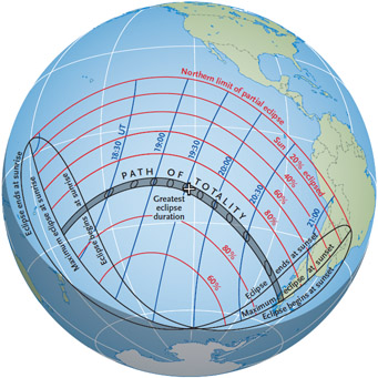
During July 11th's "ocean eclipse," the Moon's shadow sweeps across the South Pacific for 2½ hours. Red lines show the fraction of the Sun's diameter covered partially by the Moon; blue lines give the time of mideclipse along the path. Click on the image for a larger version.
S&T: Casey Reed
But unlike the spectacles in 2007 and 2008, which offered many possibilities for land-based viewing, the 6,800-mile (11,000-km) path of this eclipse is confined almost exclusively to the South Pacific Ocean. When greatest eclipse occurs, at 19:33:31 Universal Time (3:33:31 p.m. EDT), the duration on the central line is 5 minutes 20 seconds — but at a point hundreds of miles from any land.
Totality begins at sunrise almost 1,200 miles (2,000 km) northeast of New Zealand, at 18:15 UT. Five minutes later the Moon’s shadow makes the first of its very few appearances on terra firma. The island of Mangaia is a mountainous volcanic remnant in the Cook Islands just south of the eclipse path’s central line. The duration of totality here is 3 minutes 18 seconds, with the Sun 14° above the horizon.
The northern edge of the shadow’s umbra (zone of totality) just misses Tahiti in French Polynesia, passing a tantalizingly close 12 miles (20 km) south of the island. Just to the east, several atolls of the Tuamotu Archipelago are more fortunate. Tiny Haraiki and Tauere are deep in the eclipse path, but neither has facilities of any kind. On slightly larger Hikueru, which has a territorial airport, totality lasts 4 minutes 35 seconds.
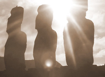
Astronomical Tours is offering an eclipse expedition to Easter Island.
Astronommical Tours / Jen Winter
Nearly 40 minutes later and 600 miles (1,000 km) farther southeast, totality crosses Easter Island, one of the world’s most remote inhabited locations. The landscape is dominated by three extinct volcanoes and 887 mysterious stone statues carved a thousand years ago by the thriving inhabitants at the time. From the capital, Hanga Roa, the Sun’s altitude is 40° during the 4 minutes 41 seconds of total eclipse. Tourism is Easter Island’s main industry, and the eclipse will bring record numbers to this remote destination.
The shadow then must travel 2,300 miles (3,700 km) to reach its final landfall in extreme southern South America. Chile’s mountainous region has no suitable viewing sites, but Argentina’s tourist resort of El Calafate offers promise as the final opportunity before the shadow’s umbra lifts from Earth at sunset and returns to space.
Weather Prospects
The eclipse fortunately occurs during the “dry” season, though this is a relative term at best for tropical and sub-tropical locations. Satellite cloud-cover data show that the sunniest spots lie at the lowest latitudes, favoring French Polynesia and the Tuamotu Archipelago.
Mangaia lies within the subtropical high-pressure belt circling the globe at 30° south latitude, but it has the misfortune to be close to the South Pacific Convergence Zone (SPCZ), where winds from the eastern and western Pacific converge. This gives Mangaia an average cloudiness of 63% and many rainy days.
Tahiti’s clear-sky prospects are better, with average cloudiness at Papeete’s airport a promising 48% and with 68% of the maximum possible sunshine (that is, 68% of daytime is sunlit). The surrounding waters are less cloudy, so prospects on the central line south of the island will be even better. The added advantage of mobility that a ship provides makes cruise ships off Tahiti the venue of choice for this eclipse.
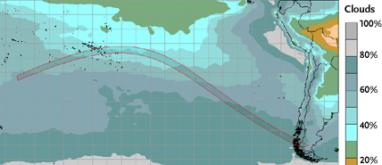
Weather prospects for July 2010's total solar eclipse aren't ideal, as this map of average cloudiness shows. The most favorable locations are the islands of French Polynesia that lie on and near the path of totality. Click on the image for a larger version.
Jay Anderson
At Hao, which is east of Tahiti and near the southern edge of the path, land-based observations show the average cloudiness to be just over 50%, and satellite observations are even more favorable.
Easter Island’s more southerly latitude dims its weather prospects. The island is often enveloped in frontal systems sweeping up from the Southern Hemisphere’s “Roaring Forties” latitudes. Average cloud cover is 69%, and the percent of possible sunshine is just 50%. The island’s volcanoes are important cloud-makers on their leeward sides, so observers are advised to select coastal sites exposed to the onshore wind.
In the South American mountains, cloud-cover prospects in the El Calafate region are reasonable with an average value of 54%. However, the low altitude of the Sun makes this a challenging venue. Low clouds are frequent during this season, probably generated in large part by the local lakes. Finding a site upwind from the lakes may make the difference in successfully viewing the total eclipse suspended just above the distant Andes peaks.
While the 2010 eclipse offers challenges to prospective eclipse viewers, it will be the last opportunity to observe the Sun’s corona for more than two years. The next total eclipse occurs November 13–14, 2012 — visible at sunrise from northern Australia but, again, tracking mostly across the South Pacific.
For More Information
NASA's Solar Eclipse Bulletin for 2010 contains detailed local predictions, tables, maps, and weather prospects. You can also obtain a free copy of the 77-page book via email request.
Astronomer Fred Espenak, a.k.a. "Mr. Eclipse", coauthored the recently published Totality: Eclipses of the Sun (3rd edition) with Mark Littmann and the late Ken Willcox. Meteorologist Jay Anderson (University of Manitoba) has made eclipse weather forecasts since 1979 and has journeyed worldwide to confirm his predictions in person.

Comments
You must be logged in to post a comment.