 0
0As Schiaparelli prepares to land on Mars, how are the other robotic denizens of the Red Planet doing?
ExoMars Trace Gas Orbiter and the Schiaparelli lander are in the final days of their journey to Mars, where they'll join a fleet of active and aging Mars missions.
Two of them, Opportunity and Curiosity, have been roving the Martian surface for years. What are they up to now?
NASA / JPL / MSSS
Opportunity
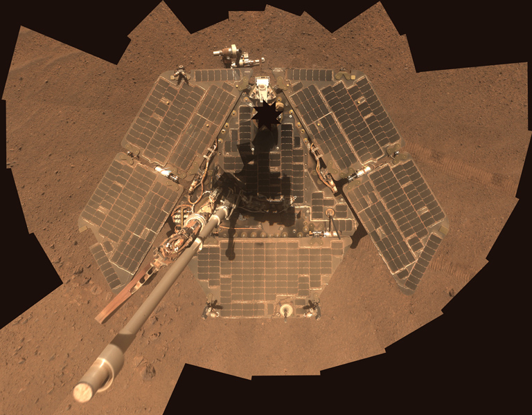
NASA / JPL-Caltech / Cornell Univ. / Arizona State Univ.
Opportunity is, as of today, on the 4525th Martian day of its planned 90-day mission. The rover is in decent health considering its age. Its right front steering motor hasn't worked since sol 453; its shoulder can't rotate side to side; it no longer has the use of its Mini-TES or Mössbauer spectrometers; and ongoing problems with its Flash memory have made the mission shift to a RAM-only mission, which means that the rover has to downlink any science data immediately or else it will "forget" the data when it shuts down overnight.
But the remaining instruments (the Pancam and Microscopic Imager cameras and the Alpha Particle X-Ray Spectrometer on the arm) work fine, as do its wheels, and NASA has repeatedly deemed the mission worth extending, year after year. The rover has driven more than 43 kilometers.
For the last 5 Earth years, Opportunity has been crawling along the rim of Endeavour crater. Impact craters lift deeply buried rocks to the surface, and Endeavour's eroded rim exposes rocks much older than the ones Opportunity landed on.
For much of 2016, Opportunity has been exploring Marathon Valley, a site along Endeavour's rim that drew scientists' attention because orbital data suggested there were clay minerals present. Clay minerals are enticing because they typically form as a result of rocks interacting with liquid water.
Sadly, the fact that Opportunity's spectrometers no longer work has made it difficult for scientists to match minerals on the ground with the observations from orbit. The science team found the rocks within Marathon Valley to be all jumbled up, probably as a result of the impact that made the crater in the first place.
There's evidence that water came through later, depositing sulfur-rich veins. It will take time to understand where the clay minerals are and what story they have to tell about Mars' watery past. In the meantime, Opportunity has driven onward and has begun its tenth extended mission, to explore an ancient, dry Martian gully.
See detailed maps of Opportunity's journey on NASA's Mars Exploration Rovers website.
Curiosity
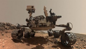
On the other side of Mars, Curiosity has also recently begun a new extended mission and is now in its 1492nd Martian day of operations. The rover is in good health, with all instruments still functional, except for a wind sensor that hasn't worked since landing.
However, its neutron sensor is now past its warrantied lifetime, and there has been a worrisome series of short-circuits in the rover's drill. The rover's thin aluminum wheels became damaged during the long traverse from the landing site to Mount Sharp, but careful driving has dramatically slowed the progression of damage, and the rover should be able to drive for many more kilometers even if they continue to deteriorate.
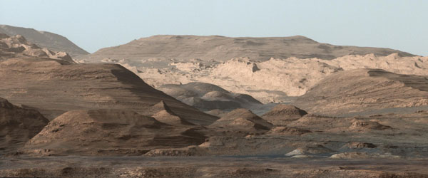
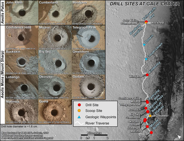
Curiosity arrived at the base of Mount Sharp about two years ago, on sol 746, and since then has spent most of its time skirting the mountain, driving west, and surveying the varied sedimentary rocks that build the mountain's base.
The rover has drilled into fine-grained mudstones that likely formed in the still waters of a lake, and into coarser sandstones that may have formed in faster-moving water or by the action of wind. All of these rocks are shot through in different places with bright veins rich in sulfate minerals, evidence that mineral-rich fluids circulated through the ground after the sediments had been buried, compacted, and turned to stone.
NASA / JPL-Caltech / MSSS / UA
Curiosity reached a major milestone on sol 1357. That's when, after 12 kilometers of driving, it finally reached a gap in an impassable field of tall sand dunes that had stood between the rover and the upper strata of Mount Sharp ever since landing day.
The rover is now headed south, crossing through a landscape of high-standing buttes that had likely been carved into their dramatic shapes by the action of wind and sand. Curiosity is currently making its way upward through Mount Sharp's layered rocks, systematically surveying their changing composition as it climbs in elevation.
Schiaparelli will soon join Opportunity and Curiosity on the Red Planet — for more on its progress, see "Schiaparelli Set to Land on Mars."


Comments
You must be logged in to post a comment.