 0
0
With a mass of roughly 180 kilograms, NASA's Mars Exploration Rovers will be able to trek up to 100 meters per day during their three-month explorations. Each lander carries a suite of five instruments, collectively called Athena, and an abrasion tool for exposing fresh surfaces on rock faces.
Courtesy NASA/JPL.
After an exhaustive two-year selection process, NASA has announced the target zones on Mars where a pair of sophisticated rovers are to land early next year. The first of these Mars Exploration Rovers (MER A) will head for a large, sediment-filled crater called Gusev, while MER B is going to the mysterious flatlands of Meridiani Planum. Both sites show ample evidence, though in different ways, that liquid water was present in ancient times.
Gusev, 160 kilometers across, appears to have been the settling pond for Ma'adim Vallis, an 800-km-long channel system that breaches the crater's southern rim. Studies suggest that water may have pooled inside Gusev for the first two billion years of Martian history, a time when the planet's climate may have been much more dynamic than it is today. Given this, biologists and geologists are eager to see what kinds of sediments might have accumulated on the crater's floor.
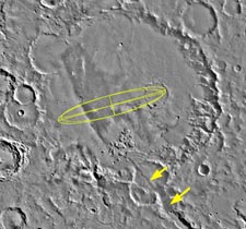
Yellow ellipses mark the likely landing zones within Gusev crater for one of NASA's two Mars Exploration Rovers. The floor of this 160-kilometer-wide basin appears to be deeply covered with sediments brought in by the Ma'adim Vallis channel (arrowed).
Courtesy NASA/JPL.
By contrast, the Meridiani site does not look outwardly like water once flowed there. However, infrared spectra from two NASA orbiters, Mars Global Surveyor and 2001 Mars Odyssey, show that Meridiani's surface contains an abundance of hematite. This iron-rich mineral can form in several ways, most of which (but not all) involve liquid water. Geologists continue to debate whether the hematite precipitated directly from a standing body of water or arrived as volcanic fallout that was later modified by hot fluid percolating up from below.
Notably, MER B will come to rest precisely in the area of Mars where telescopic observers have reported seeing enigmatic flashes, which may be reflections from low-lying clouds of water-ice crystals or even patches of surface ice. Observations from Mars Odyssey's neutron spectrometer support the notion that water ice lies just below the surface in this region.
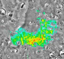
Areas of red and yellow in this color-coded overlay indicate places in Meridiani Planum (also known as the dark telescopic feature Sinus Meridiani) that contain at least 10 to 15 percent hematite, an iron-rich mineral that most likely was deposited or altered by water. The color data come from the Thermal Emission Spectrometer aboard NASA's Mars Global Surveyor.
Courtesy Philip Christensen and the TES team.
True to his mandate that NASA's Mars-exploration program must "follow the water," Edward J. Weiler, the agency's associate administrator for space science, made the final site selection earlier this week. In the end, he picked the two locations that mission scientists had most fervently hoped for. But coming to that conclusion required a tedious winnowing process that began in 2001 with 185 potential sites. Of these, 25 received close scrutiny, from which emerged the four finalists examined by an independent review board and finally by Weiler.
"It doesn't matter how good the science is if you can't land safely," observes Matthew Golombek, who cochaired the team charged with the selection process. For example, both landing sites needed to straddle the equator, as MER A's touchdown must occur in the latitude range of +5° to –15° and MER B's between –5° and +15°. Winds had to be calm, the surface not too rough, and slopes gentle. The target areas had to lie at least 1.3 km below the Martian equivalent of sea level, because at higher elevations the wisps of Martian atmosphere are too thin for the MER descent parachutes to function. "This leaves only 5 percent of Mars," Golombek notes, and the target zones needed to be big enough (roughly 110 by 20 km) to allow leeway for navigation errors or trajectory uncertainties during descent through the atmosphere.
The two runner-up sites were a large, low-lying basin called Isidis Planitia and a broad, flat plain in the Elysium region. (However, Isidis has been chosen as the landing site for the British-built Beagle 2 spacecraft.) One strong candidate that did not make "final four" involved Melas Chasma, one of the major branches of the Valles Marineris canyon complex. Scientists loved the idea of setting a rover down on the canyon's broad, thickly layered floor – but the mission's engineers did not.
NASA's timetable calls for MER A to leave Earth on June 6th (8 days later than originally planned, due to technical problems), arriving at Gusev next January 4th. MER B's launch is set for June 25th, with touchdown on Meridiani taking place seven months later on January 25th.

Comments
You must be logged in to post a comment.