 5
5The upcoming annular solar eclipse will be the best such event visible from the U.S. in decades — with a stunning "ring of fire" observable from California to Texas.
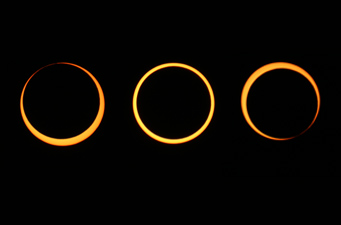
Michael Gill traveled from Birmingham, England, to Kourou, French Guiana, to witness an annular eclipse on September 22, 2006. This sequence shows (from left) the event's second contact, midpoint, and third contact.
Michael Gill
Eclipse-lovers haven't experienced a "central" solar eclipse from U.S. soil in nearly two decades (1994, to be exact). But those of you out west will soon have a good chance of seeing one on May 20, 2012, when the path of an annular eclipse covers a wide swath from northern California to the Texas Panhandle.
May's event is called an annular or "ring" eclipse because the Moon passes directly in front of the Sun but will cover only 88% of it. The undersize lunar disk results because the eclipse occurs just one day after the Moon reaches apogee, the most distant point in its orbit around Earth. So the black lunar silhouette will appear completely surrounded by the Sun's disk from a generously wide path that's at least 150 miles (240 km) across. Astronomers refer to this kind of incomplete lunar shadow as an antumbra.
| Weather prospects:Here is a summary along the U.S. eclipse path provided Sunday morning by eclipse meteorologist Jay Anderson. (Check his website for last-minute updates): The central and western part of eclipse track are forecast to be largely cloud free. An incoming Pacific system has slowed, so that California and Nevada look good. The morning satellite image shows a big blob of low cloud north of Lubbock, extending into east-central New Mexico. This stuff should dissipate fairly early in the day. However, it is a sign of moisture in the lower atmosphere, and it will burn off by first turning into cumulus. The most significant threat area is near Carlsbad, New Mexico, as the short-range model shows cloud and rain in this area by eclipse time. So anyone at the southeastern path limit should consider a different destination. The latest model offers some encouragement for Lubbock area, though this city is not yet out of the woods. For the rest of the track, almost nothing is happening in the lastest infrared satellite image. Even the system expected over Colorado and northeast New Mexico is little more than high-level cirrus at present, a sign of upper-level forcing that will probably help the development of shower clouds later in the day. All in all, it's probably about the best weather situation I could have imagined for today. |
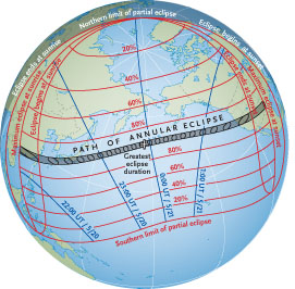
The path of May’s annular eclipse stretches from China to the western United States. Red lines show the maximum percent of the Sun’s diameter covered, and black lines show when this occurs, for locations where a partial eclipse is visible. Click on the image for a larger version.
S&T illustration; source: F. Espenak
WARNING: Because the Sun's disk won't be completely covered, you'll need to take careful precautions when attempting to view the ring or any phase of the partial eclipse. Looking at the Sun with your bare eyes, or with an inadequate filter, can permanently damage your vision.
There are several good ways to observe the Sun safely. You can view through special "eclipse shades" (not regular sunglasses) or a #13 or #14 rectangular arc-welder's glass. You can set up your telescope or even tripod-mounted binoculars to project the Sun's image onto a white card or other flat surface, and watch that. Special solar filters are also made to fit over the front of your telescope. Check out these safe eclipse-viewing options recommended by the editors of Sky & Telescope.
Or you can watch the eclipse online.
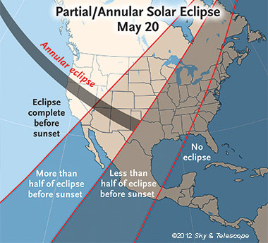
Nearly all North America gets at least a partial eclipse on May 20th, with the Moon taking a big bite out of the Sun. The eclipse will still be in progress at sunset for much of the U.S., Canada, and Mexico. Click image for larger view.
A Transpacific Eclipse
The event is first seen across Southeast Asia at dawn. The city of Guangzhou in southern China sits within the eclipse track, as do Tokyo, Osaka, and Yokohama in Japan, along with Hong Kong and Taipei. That's 36 million people in those six cities alone! Weather permitting, easily more than 100 million early-risers in Asia could see this ring eclipse. Then the Moon's shadow races 4,000 miles (7,000 km) eastward across the Pacific, narrowly missing Alaska's Aleutian Islands before making landfall along the California-Oregon border. By then it's already late afternoon locally.
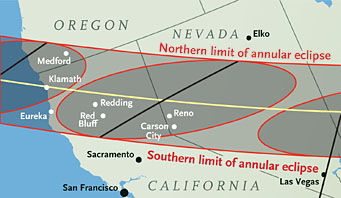
Many towns in southwest Oregon (such as Medford), northern California (Eureka, Redding), central Nevada (Reno), southern Utah (St. George), northern Arizona (Flagstaff) and New Mexico (Albuquerque), and northern Texas (Lubbock) lie within the annular zone. Remember: the farther east you are along the track, the more important it becomes to find a clear western horizon. The table below shows a sampling of well-positioned cities and towns.
| Circumstances for May 20th's Annular Solar Eclipse | ||||
| City | Annular eclipse begins | Annular eclipse ends | Duration | Sun's altitude |
| Medford, OR | 6:24:33 | 6:27:19 | 2m 46s | 21° |
| Eureka, CA | 6:25:50 | 6:29:50 | 3m 59s | 21° |
| Redding, CA | 6:26:21 | 6:30:56 | 4m 35s | 20° |
| Reno, NV | 6:28:32 | 6:32:58 | 4m 26s | 17° |
| Grand Canyon, AZ | 6:34:01 | 6:37:26 | 3m 17s | 10° |
| St. George, UT | 7:32:17 | 7:36:30 | 4m 13s | 11° |
| Albuquerque, NM | 7:33:39 | 7:38:05 | 4m 26s | 5° |
| Lubbock, TX | 8:33:55 | 8:38:08 | 4m 13s | 1° |
Sky & Telescope has compiled an list of predicted times for more than 40 places along the path (12-hour clock or 24-hour clock). This interactive Google map lets you zoom in on any point along the track.
May's path of annularity extends from the coastline at the California-Oregon border to northwestern Texas. Shaded ovals give “snapshot†representations of the Moon’s antumbral shadow at approximately 5-minute intervals. Click here for a larger view of the entire U.S. path.
S&T illustration; source: F. Espenak
More than 30 U.S. national parks lie within or very near the path as well, and the National Parks Service is getting ready to host big crowds of expectant visitors. Here's a list of public events.
Veteran eclipse-chasers sometimes debate whether it's best to view an annular eclipse from the path's centerline versus near its edge at the northern or southern limit. Centerline locations have the advantage of briefly showing the lunar disk precisely concentric with the Sun's. However, edge-viewers enjoy an extended display of "Baily's beads" — the momentary flashes of sunlight peeking through valleys along the lunar limb.
Similarly, observers in California have the advantage of seeing the Sun well up in a late-afternoon sky. That's a definite plus if your western horizon is partially obstructed, and you'll be able to watch the entire 2½-hour-long event — from the first little nibble of the lunar disk to the last. On the other hand, there's no denying the dramatic possibilities farther east, say in eastern New Mexico, when the Sun-Moon encounter hangs just above the horizon's sunset point.
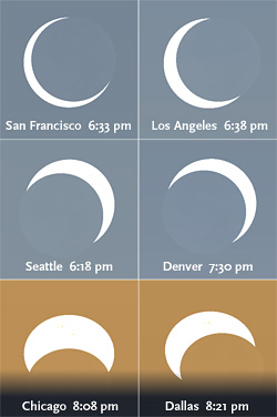
Weather permitting, most North Americans will see a dramatic partial solar eclipse on May 20th. Here's the simulated view at mid-eclipse from six major U.S. cities. For Chicago and Dallas, maximum eclipse occurs at sunset.
Sky & Telescope diagram / source: Stellarium
For those who can't get to the path of annularity, most of North America will see at least a small bit taken out of the Sun that day — and many will enjoy a very deep partial eclipse.
For example, San Franciscans will see the Sun 84% covered at 6:33 p.m.; from Denver, it's 79% at 7:30 p.m.; and those in Dallas will see 67% of the Sun missing as it slips below the western horizon. Find out the predicted circumstances for Asia and Canada and for locations across the United States.
Weather Forecasts
As for weather prospects, "May is not a good time to start an eclipse in Asia," notes meteorologist Jay Anderson, "but it’s a very good time to end one in North America." The monsoon season is under way in southeastern Asia by eclipse day, and statistically many locations along the path in southern China have an 80% chance of cloudy skies.
By contrast, late-spring weather is generally fair in California, and the start of monsoon season in the American Southwest will be weeks away. "This eclipse is tailor-made for U.S. observers," Anderson concludes. For details, check out his comprehensive weather analysis for various eclipse locations.
Curiously, this late-spring event will be the first eclipse of 2012. Get details about other eclipses on this year's calendar.


Comments
Subscriber BJ
March 5, 2012 at 3:20 pm
Thanks for the new 'Observing Section' in S&T! Great idea. I've always pulled the Sky Dome and it's attachments (the heavy pages) from the mag to use in my observing binder at my scope. In the past that has almost always resulted in the loss of part of another article. The new way is great! Now I can get all the observing articles without disemboweling some other great article. Thanks Again!
You must be logged in to post a comment.
Jay Arthurs
April 3, 2012 at 11:23 am
My wife and I live in California and are going to try to see Baily's Beads on the May 20 annular eclipse as Kelly Beatty suggested. We saw the 1994 annular as the full annular so we thought we'd try something different this time around. However, Kelly's article states that the edge uncertainty of the path prediction is on the order of 1-2 km. If we set up at some particular spot we might wind up missing them altogether. It would be great if there was some way to find out what others are seeing earlier along the path. If they could tell us the moon is running north or south of the predicted position we might have time to move along the road to be in a better position to see the beads. Is there any way we might find out this information? We could bring our laptop with us to try to tune in to some website that might tell us this info.
Thanks.
You must be logged in to post a comment.
Michael Galindo
May 7, 2012 at 5:18 pm
Great article. Me and my Dad are going to observe the eclipse at the VLA in New Mexico. We have been using S&T to plan the whole trip. Your maps and graphics are way better than the others. Great Work!!!
Thank you for all this.
You must be logged in to post a comment.
Kelly Beatty
May 7, 2012 at 5:20 pm
Jay... I don't see where I said the path is uncertain by 1-2 km. in any case, there's really no uncertainty in the path's position. a location closer to the edge crates extended Baily's Beads. to a first approximation, 1 km from the path's edge on Earth corresponds to 1 km of lunar topography. so if you want to guarantee that you'll see (or image) the Moon completely inside the Sun, and yet still see lots of Baily's beads, you'd want to be inside the southern limit by a few kilometers. check out the interactive Google Map with the eclipse path here: http://eclipse.gsfc.nasa.gov/SEgoogle/SEgoogle2001/SE2012May20Agoogle.html. I've been right at the edge before (in Spain, several years ago), and I found that by eye it looked like the solar ring was broken (= partial eclipse), even though the annulus was complete when viewed telescopically. so choose your location accordingly.
You must be logged in to post a comment.
jaime
May 20, 2012 at 9:20 am
great article,Thanks, and have a good astronomic time
You must be logged in to post a comment.
You must be logged in to post a comment.