 0
0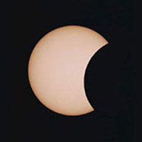
The advancing Moon takes a bite out of the Sun in this image taken on May 10, 1994.
S&T image: Rick Fienberg.
On April 8, 2005, the southern U.S. (excluding the west coast) will catch the fringe of a solar eclipse that will be a much bigger show elsewhere.
The center of the eclipse will alternate from annular to total and back to annular along a narrow path crossing the South Pacific and ending near sunset for parts of Costa Rica, Panama, Colombia, and Venezuela. (Totality occurs at sea and at maximum lasts a mere 42 seconds.) In addition, Central America, the Caribbean, and parts of South America get a deeper and more spectacular partial eclipse than we northerners do.
Of course, never look at the Sun — either with the naked eye or through an optical instrument — without a safe solar filter. There are also other ways to watch safely.

To find when the eclipse will begin at your location, interpolate between the blue lines. To find the end time, use the red lines. Deepest eclipse occurs halfway between. Universal Times are given; subtract 4 hours from this to get Eastern Daylight Time, 5 hours to get CDT, 6 to get MDT, or 7 to get PDT. (Subtract another 12 hours to get times p.m.) The black lines tell what percentage of the Sun’s diameter will be covered at mideclipse.
S&T illustration.
If you’re south of the "Northern Limit" line on the map below, be sure to examine the Sun on Friday afternoon. Shortly before sunset on the East Coast, and earlier in the afternoon farther west, the edge of the new Moon will graze the Sun’s rim. The blue and red lines on the map show, in Universal Time, when the eclipse will begin and end, respectively. (Subtract 4 hours from Universal Time to get Eastern Daylight Time, 5 hours to get CDT, 6 hours to get MDT, or 7 hours to get PDT or MST.) Interpolate between the lines to find when the partial eclipse begins and ends at your location.
The black lines on the map show the magnitude of the eclipse: what percentage of the Sun’s diameter will be covered at the time of maximum, midway between the beginning and end. (Click on the map for a larger version that includes Central America and the northwestern corner of South America.) The views above show how the Sun will look at maximum eclipse from various cities.

To find when the eclipse will begin at your location, interpolate between the blue lines. To find the end time, use the red lines. Deepest eclipse occurs halfway between. Universal Times are given; subtract 4 hours from this to get Eastern Daylight Time, 5 hours to get CDT, 6 to get MDT, or 7 to get PDT. (Subtract another 12 hours to get times p.m.) The black lines tell what percentage of the Sun’s diameter will be covered at mideclipse.
Click on the map for a larger view. Or see a world version in low or high resolution, or a closeup of the centerline over land. An animated partial-eclipse map is available from Science@NASA in English or en Español.
Sky & Telescope illustration.
For skywatchers across much of the southern United States, here are the local civil (clock) times when the eclipse begins and ends for 20 locations, as well as the time of mid-eclipse and the altitude (alt) of the Sun at all three times.
| Partial Solar Eclipse, April 8, 2005 | ||||||
| Location | First contact |
Sun's alt |
Mid-eclipse |
Sun's alt |
Last contact |
Sun's alt |
| Albuquerque, NM | 3:39 p.m. | 46° | 4:03 p.m. | 41° | 4:26 p.m. | 37° |
| Atlanta, GA | 5:35 p.m. | 30° | 6:18 p.m. | 21° | 6:59 p.m. | 13° |
| Charlotte, NC | 5:42 p.m. | 25° | 6:19 p.m. | 18° | 6:55 p.m. | 10° |
| Columbus, OH | 6:06 p.m. | 22° | 6:17 p.m. | 19° | 6:29 p.m. | 17° |
| Dallas, TX | 4:26 p.m. | 42° | 5:11 p.m. | 33° | 5:53 p.m. | 24° |
| Houston, TX | 4:17 p.m. | 44° | 5:11 p.m. | 32° | 6:02 p.m. | 21° |
| Jacksonville, FL | 5:28 p.m. | 30° | 6:20 p.m. | 19° | 7:07 p.m. | 8° |
| Kansas City, MO | 5:03 p.m. | 31° | 5:12 p.m. | 29° | 5:22 p.m. | 27° |
| Memphis, TN | 4:38 p.m. | 34° | 5:15 p.m. | 26° | 5:52 p.m. | 19° |
| Miami, FL | 5:20 p.m. | 31° | 6:20 p.m. | 17° | 7:14 p.m. | 5° |
| New Orleans, LA | 4:21 p.m. | 38° | 5:15 p.m. | 27° | 6:05 p.m. | 16° |
| Oklahoma City, OK | 4:37 p.m. | 39° | 5:10 p.m. | 33° | 5:43 p.m. | 26° |
| Philadelphia, PA | 6:07 p.m. | 15° | 6:19 p.m. | 13° | 6:32 p.m. | 11° |
| Phoenix, AX | 2:35 p.m. | 51° | 2:57 p.m. | 47° | 3:19 p.m. | 43° |
| Pittsburgh, PA | 6:12 p.m. | 18° | 6:18 p.m. | 17° | 6:24 p.m. | 16° |
| Richmond, VA | 5:52 p.m. | 20° | 6:20 p.m. | 15° | 6:46 p.m. | 9° |
| San Antonio, TX | 4:14 p.m. | 47° | 5:09 p.m. | 35° | 6:00 p.m. | 25° |
| St. Louis, MO | 4:55 p.m. | 29° | 5:15 p.m. | 26° | 5:34 p.m. | 22° |
| Tucson, AZ | 2:25 p.m. | 53° | 2:58 p.m. | 47° | 3:30 p.m. | 41° |
| Washington, DC | 5:59 p.m. | 19° | 6:19 p.m. | 14° | 6:40 p.m. | 11° |
Sky & Telescope has also computed a larger timetable for many more cities and towns across North America. It is available here as a 23-kilobyte PDF file, which you can download using anonymous FTP and open on any computer using the free Adobe Reader software.
For locations outside the United States, predictions are available (in Universal Time) at the NASA eclipse site. NASA also lists any further information you may want.
Wish you could be on the centerline? Try these links to webcasts planned from places where the eclipse will be annular or total!

Comments
You must be logged in to post a comment.