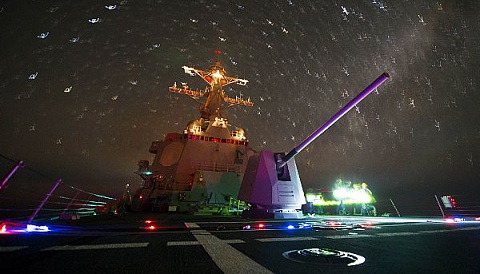
 6
6Modern security threats have brought back an old method — celestial navigation — to help U.S. Navy sailors navigate the high seas.
Mass Communication Specialist 3rd Class Paul Kelly / U.S. Navy
It's a scene straight out of a Tom Clancy novel. An adversary, seeking to gain the upper hand, manages to blind GPS satellites in a first strike. As alert levels rise and military leaders attempt to assess the situation, ships at sea must somehow get an accurate fix of their position . . . without the use of modern technology.
The United States Navy recently recognized modern vulnerabilities by bringing back an old method for navigating at sea: the Naval Academy in Annapolis, Maryland, has just resumed training officers in the lost art of celestial navigation. Although this training used to be standard in the U.S. Navy, the advent of GPS technology so simplified and improved the ability to find a ship's position at sea that the Navy ROTC ended celestial navigation training in 2000, and the U.S. Naval Academy phased it out as well in 2006.
But the U.S. Navy and the Department of Defense are taking cyber threats to technological infrastructure seriously. Commercial GPS jammers are now readily available on the internet. And while the U.S., China, the European Union, Russia, and India are all moving to assure they have their own exclusive GPS network in orbit, a deliberate attack may not even be necessary. A space debris chain reaction known as an ablation cascade could knock out our GPS capability, or a strong Earth-directed solar storm such as the 1859 Carrington super-flare event could do the job just as well.
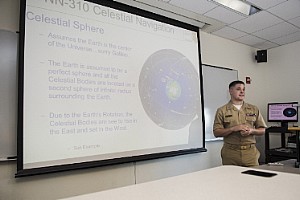
"There is an effort throughout the Navy for midshipmen, officers, and sailors to become more familiar and comfortable with celestial navigation," says Lt. Daniel Stayton, an instructor of the U.S. Naval Academy CELNAV course. "We are currently in the first steps of reintroduction back into the fleet."
The U.S. Naval Academy brought back celestial navigation theory for its 2015 summer session, and the graduating class of 2017 will be the first in more than a decade with basic instruction in celestial navigation theory.
Mass Communication Specialist 2nd Class Scott Raegen / U.S. Navy
Losing Our Way — and Finding It Again
This sort of "back to basics" approach echoes a growing refrain: our over-reliance on GPS has made navigational skills all but vanish. My wife and I are the first to admit, it's both amazing and a little scary just how reliant we've become on Google Maps as we travel in Europe. Then again, I also remember that same GPS technology used to lead would-be visitors to our Florida home down a nearby dead-end street.
Mass Communication Specialist 2nd Class Tyler Caswell / U.S. Navy
Although the U.S. military pioneered the development of GPS technology in the 1970s, widespread civilian use only came after May 2000, when President Clinton directed the removal of intentional inaccuracy (known as selective availability, a precaution to assure an enemy wouldn't utilize GPS) that had been built in to early commercially available systems. The U.S. Navy now typically uses the Voyage Management System developed by Northrop Grumman for navigation at sea.
But for centuries sailors had found their way using the stars.
Celestial Navigation: The Basics
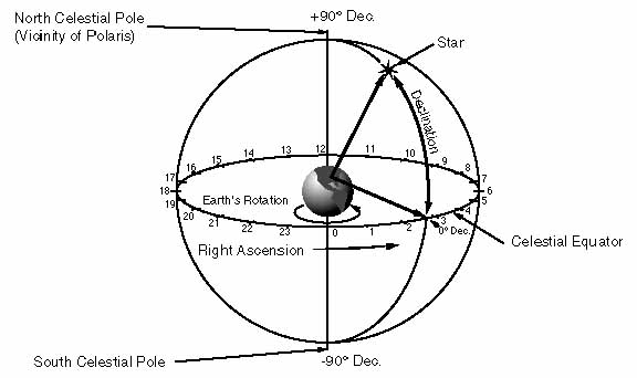
In the Northern Hemisphere, it's pretty straightforward to find latitude by noting the elevation of the star Polaris, which marks the celestial north pole. Navigators can also measure the Sun's elevation at noon. Discerning longitude, however, is trickier and requires accurate timekeeping.
University of Durham
From the surface of the Earth, the imaginary sphere of the sky along the celestial equator appears to rotate 15 degrees per hour. In fact, we mark off right ascension in the sky — analogous to longitude of the surface of the Earth — in hours, minutes, and seconds. A land-based observatory will therefore see a celestial object rise, transit the local meridian bisecting the sky from north to south, and set at a different time than a ship at sea.
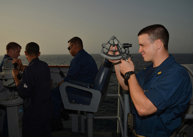
A navigator would note stars' positions using a sextant to measure the angle between each star and the horizon. Then the navigator would compare the measurement to an almanac published for a particular location. With this painstaking method, a seasoned celestial navigator could reckon a ship's position down to about two kilometers.
Getting an accurate fix on longitude, however, had to wait for accurate timekeeping. Early efforts relied on complex lunar tables. By the mid-19th century, such methods improved and longitude measurements became increasingly accurate. Some clever methods were devised as well: Christopher Columbus and Captain Cook both made use of lunar eclipses to gain one-time measurements of their positions at sea. Astronomers of the day also proposed using the transits of Jupiter's moons in a similar fashion, though observing such events from the deck of a pitching ship at sea proved problematic.
Apollo astronauts even practiced celestial navigation on their missions to the Moon, in the event that a loss of communication meant they had to find their own way home.
"Redundancy improves readiness," notes Stayton. "If the Navy is able to add an additional layer of redundancy . . . by merely teaching a skill, then an opportunity exists to improve readiness throughout the fleet."
It's great to see an old method brought back to guide the modern tech-savvy military. Perhaps we should all take a cue from the U.S. Navy and keep those paper maps handy the next time we head out on our next GPS-guided adventure . . . just in case.


Comments
Anthony Barreiro
April 5, 2016 at 1:56 pm
I think it's great that the Navy is once again teaching sailors to navigate. As Lieutenant Stayton says, redundancy improves readiness.
When I'm driving somewhere unfamiliar, I always look at a map before I start traveling -- preferably a printed map, but a digital map works too -- and figure out where I'm going before I leave. I would feel lost and disoriented if I were just following turn-by-turn instructions from a mobile device. And what do you do if the battery dies or you can't get a signal?
You must be logged in to post a comment.
Frank-ReedNavigation.com
April 5, 2016 at 2:15 pm
This story broke six months old, and it has been frequently mis-represented in media re-tellings. The US Navy is NOT throwing out its GPS sets! 🙂 You can hear me interviewed on NPR last fall here: http://hereandnow.wbur.org/2015/10/15/navy-celestial-navigation.
From a practical standpoint, celestial navigation is, at best, the backup to the backup to last backup. I teach many classes in celestial navigation (including one in "Modern Celestial Navigation" this coming weekend at Mystic Seaport in Mystic, Connecticut), and I always remind participants that "the best backup to a GPS is another GPS". The US Navy is adding some very basic elements of celestial navigation back into their curriculum, but they clearly see it something that's 'good for you' in principle even though it's not much use in practice. Celestial navigation, after all, suffers from one enormous weakness --it's useless in cloudy weather-- which is why it was replavced by electronic methods decades ago (GPS being the most recent and most successful addition to the toolkit).
Nevertheless, the Sun and the stars, when skies are clear, provide navigational information. And no navigator should ever ignore any information that is available. If you can see the Sun, then you should know its exact azimuth (compass direction) at all times, and its predicted altitude, possibly to be compared with a sextant observation should be available at all times. These basic elements can secure "situational awareness" and keep us from making deadly errors. It's a guard against the biggest threat we face: human error.
Frank Reed
ReedNavigation.com
You must be logged in to post a comment.
Anthony Barreiro
April 5, 2016 at 7:53 pm
Good point about the value of incorporating all available information to maximize situational awareness. In a different context, when I'm doing public skywatching outreach, someone will often ask me if a particularly bright star is the north star. I ask them to get their bearings (e.g. from local streets or landmarks) and figure out which way is north. When they figure out that the star they're looking at is toward the south, east, or west, it's easier for them to deduce that it's probably not the north star.
You must be logged in to post a comment.
Frank-ReedNavigation.com
April 5, 2016 at 2:47 pm
The article mentions celestial navigation aboard the Apollo spacecraft. This consisted of two radically different procedures, one of which mattered critically and was similar to a compass check --but not an example of position-finding, while the other --analogous to traditional marine celestial position-finding-- was obsolete by the time the moon missions occurred.
The "compass check" involved sighting a known star for direction to re-align the inertial navigation platform which was essential for firing the rockets in the right directions. This directional check was the only critical navigational procedure that had to be performed regularly by the astronauts aboard the spacecraft and could not be replaced by data from Mission Control. Today, directional checks like this are still performed regularly by spacecraft, but today automated star trackers do the work.
The Apollo spacecraft was built with a true sextant, fitted right into the hull of the spacecraft and tied directly to the inertial platform and the guidance computer. Originally, it was intended that astronauts would shoot sights, quite similar to historical "lunars", which would allow them to determine their positions on three-dimensional "cones of position" in space. This system was proposed and developed long before the rest of the Apollo systems and well before the issues of space navigation had been explored. By 1968, at the time of Apollo 8, the first flight of an Apollo spacecraft to lunar space, radio signal navigation from Earth was found to be superior to anything that could be done with the Apollo sextant. Although Jim Lovell on Apollo 8 extensively practiced celestial navigation with the sextant, and as a Navy man clearly enjoyed it, it was already merely a backup, and on later missions this position-finding capability was largely ignored. During Apollo 13, when backup navigation was needed, the impressive sextant system was useless, partially because the spacecraft was surrounded by a vast cloud of ice crystals which made identifying the stars difficult, and primarily because the sextant required power and a computer connection as well. As portrayed in the film, even for the basic "compass check" function, they had to "make do" with simple visual alignments.
More on "space sextants" in a little article I wrote here: http://fer3.com/arc/m2.aspx/g14170
Frank Reed
ReedNavigation.com
You must be logged in to post a comment.
David DickinsonPost Author
April 6, 2016 at 4:30 am
Hi Frank,
Thanks for the additional info... the use of celestial navigation on the Apollo missions as a possible backup is a fascinating tale, with a deeper backstory than the scope of the article allowed. Astronaut Al Worden also mentions testing its use during Apollo 15 in his autobiography, Falling to Earth.
You must be logged in to post a comment.
Lindsay
April 8, 2016 at 10:56 pm
Good move! And, for cloudy nights, every ship should also have inertial navigation systems.
You must be logged in to post a comment.
You must be logged in to post a comment.